This is Modi's election. And in that, this election is a battle for Indians to wrestle back their identities that have been assaulted and demonized. In order to facilitate colonial structures that perpetuate slavery. This Indian election is an exercise in freedom.
The Case against Patanjali by Indian Medical Association and the tone of Judiciary is alarming. We need to look into its historical and global context to fully grasp its ramification.
Why do seemingly normal people commit atrocities and genocides? More importantly, why do millions other go along with these crimes as participants? We explore the Perpetration-Induced Trauma and its impact on the societies.
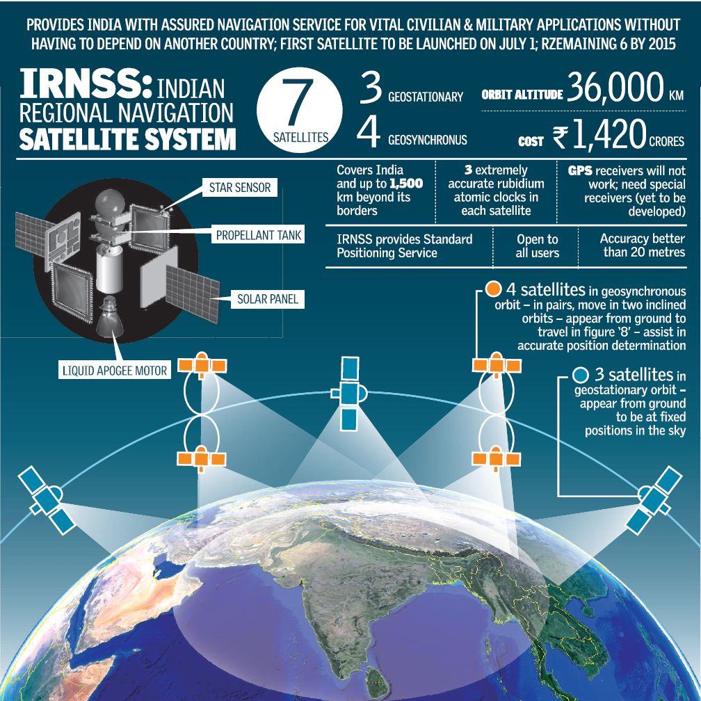
The Indian space flight workhorse PSLV-C33 shot off on its 35th flight to launch India’s 7th navigational satellite – a 1425 kg IRNSS-1G satellite, part of the Indian Regional Navigation Satellite System (IRNSS). The launch was into a sub geosynchronous transfer orbit with a perigree (nearest point to earth) of 284 km and an apogee (farthest point to earth) of 20,657 km.
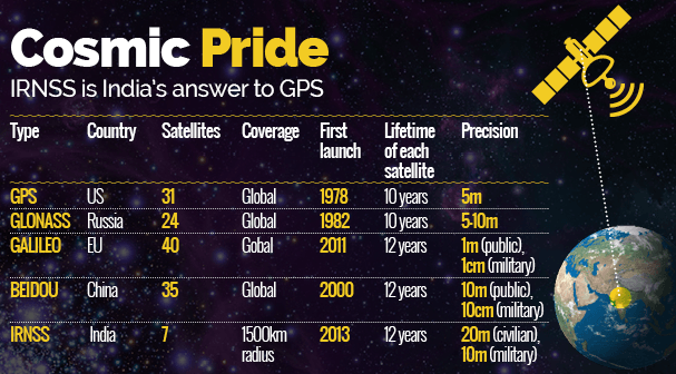
This entire system will create India’s own navigational system called NAVIC (Navigation with Indian Constellation). There are four other navigational systems in the world – Global Positioning System (GPS) from USA, GLONASS from Russia, Galileo from European Union and Beidou Navigation Satellite System (BDS) from China.
Comparisons of Navigation systems from US, EU, Russia, China and India (Courtesy: TOI)
Now Indian Space Research Organisation (ISRO) will focus on work on the front end chips that receive the navigational signals sent out by the satellites. The Indian PM was there to applaud the achievement of ISRO.
“We are now one of five countries with our own navigational system. Today we are free of dependence on other countries for navigation. Our planes will be able to land with ease and accuracy, we can plan disaster relief better and with our own technology,” a proud Mr. Modi said.
Why Get our Own Navigational System?
Many lay people will wonder – Seven satellites and all this work for what? Getting just a GPS for the cars and planes? Really? Well, navigation systems like GPS serve many more purposes specially when they are equipped with a more detailed resolution.
At the height of Kargil war, when the Pakistanis were perched at the Himalayan heights, to fight our battles the troops needed the navigational system to launch precise strikes. India approached the US for accessing their GPS. US refused point blank. India was left to fight the battles blind!
That was when Indian establishment felt the need for a navigational system acutely. The IRNSS was born then.
“Geopolitical needs teach you that some countries can deny you the service in times of conflict. It’s also a way of arm twisting and a country should protect itself against that,” said S Ramakrishnan, director of Vikram Sarabhai Space Centre, Thiruvananthapuram. This is the reasoning behind two types of services that IRNSS will be offering. The first is called Standard Positioning Service (SPS) which is for civilian use. This will have an accuracy of 20m, while the second is called Restricted Services (RS), which can detect movement of objects by less than 10m.
“Many weapon systems like guided missiles and bombs also use such navigation systems. An indigenous system allows the development of such capabilities in a reliable manner,” said Ramakrishnan. “There is also the need to have your own navigation system in the civilian and commercial domain since so many critical services and businesses depend on it. A system run by another country (like GPS) may be switched off in times of crisis leading to complete collapse of certain services.”
With US, Russia, European Union and China already having their own navigation system, India now untethers its own defence needs – as well as commercial needs from the blackmailing by these powers. Specially at times of wars when survival of our brave men and women is at stake.
So, if someone asks you why we need our own “GPS” – you need to be sure why.
Every Sunday AM (US Time)/ PM (India time), we send out a weekly detailed newsletter. We also share other insightful notes during the week. Its free. Do sign up and share with friends!